


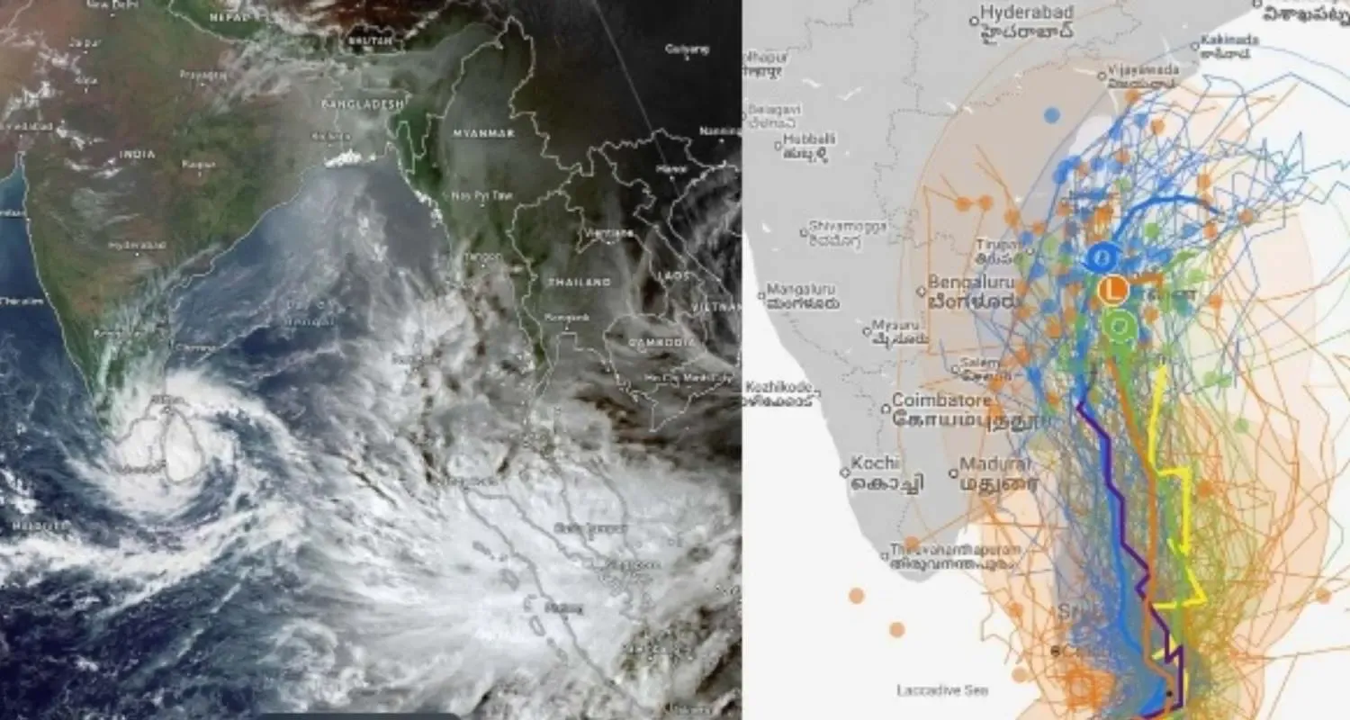
The India Meteorological Department (IMD) has announced that Cyclonic Storm Ditwah has begun advancing toward the north Tamil Nadu, Puducherry and south Andhra Pradesh coasts, raising concern among coastal authorities as weather conditions intensify over the southwest Bay of Bengal. In its latest bulletin released late Friday night, IMD confirmed that the storm, positioned near coastal Sri Lanka, is moving northwestward at a speed of 8 kmph and is projected to reach near the southwest Bay of Bengal close to the Indian coastline by the morning of November 30. The update signals the potential onset of heavy rain, rough sea conditions and intensifying winds across several coastal districts over the next 48 hours.
Current System Position and Progression
According to IMD officials, Cyclone Ditwah was centered at 23:30 IST on November 27 near latitude 7.9°N and longitude 81.3°E, located approximately 8 km northwest of Batticaloa in Sri Lanka, 80 km south of Trincomalee, and 200 km north-northeast of Hambantota. From the Indian coast perspective, the cyclone was positioned nearly 480 km south-southeast of Puducherry and 580 km south-southeast of Chennai, clearly indicating a gradual but consistent movement toward the northern parts of Tamil Nadu and Puducherry, and the adjoining south coastal region of Andhra Pradesh. Meteorologists tracking the system have noted that sea surface temperatures and wind patterns could further strengthen the storm as it progresses.
Forecast and Expected Coastal Impact
The IMD expects Cyclone Ditwah to continue its north-northwest trajectory across the coast of Sri Lanka and into the southwest Bay of Bengal, nearing land proximity by November 30 morning. With the system predicted to intensify during its journey over warm ocean waters, several coastal districts in Tamil Nadu including Chennai, Cuddalore, Villupuram, Nagapattinam, Mayiladuthurai and Chengalpattu may face strong winds and heavy rainfall. Puducherry is expected to experience rough sea conditions and potential urban flooding in low-lying areas. In Andhra Pradesh, regions such as Tirupati, Nellore and Chittoor are likely to witness weather disturbances, heavy rainfall spells and thunderstorm activity during the peak period of the system’s impact. Authorities have urged caution as rough sea conditions may lead to disruptions in fishing, port operations and marine transport.
Administrative Preparedness and Response Measures
Government agencies across the coastal states have intensified monitoring and emergency mechanisms as a precautionary measure. District administrations are preparing storm response systems including safety evacuations in vulnerable coastal belts, the deployment of the National Disaster Response Force (NDRF) and the activation of emergency control rooms. State disaster management officials are closely assessing reservoir levels, drainage systems and flood-prone zones as they prepare to address potential disruptions to electricity, transportation, water supply and essential services. Urban local bodies have begun clearing stormwater drains and trimming roadside trees to prevent obstructions caused by heavy winds and rainfall.
Marine and Fishing Community Warnings
The IMD has issued a strict marine advisory urging fishermen to avoid venturing into the southwest Bay of Bengal, central Bay regions and ocean areas along the Tamil Nadu–Puducherry–Andhra coastline due to high waves and squally wind speeds. With growing turbulence over open waters, rough to very rough sea conditions are expected to persist for several days. All fishing boats already at sea have been instructed to return to shore immediately, and coastal officials are using public address systems and harbour surveillance to reinforce safety messaging. The fisheries department is coordinating with coastal villages to ensure timely movement to safe shelters wherever required.

Public Safety and Monitoring Advisory
Authorities have urged citizens across Tamil Nadu, Puducherry and Andhra Pradesh to follow weather updates strictly from IMD bulletins and official disaster management channels, rather than relying on unverified information that can cause panic. Residents are encouraged to stock essential supplies, secure loose objects around residences, and stay updated regarding school closures and travel advisories if conditions intensify. Emergency teams have recommended that the public avoid seashores, open water bodies, damaged structures and unnecessary travel during the peak period of impact. Transport disruptions including flight delays, train schedule adjustments and blocked roadways cannot be ruled out depending on the storm’s intensity and trajectory.
Continued Monitoring and Preparedness Crucial
As Cyclone Ditwah advances toward the Indian coastline, the situation remains closely monitored by meteorological and disaster management agencies. The current forecasts indicate that November 29 and 30 will be crucial days for Tamil Nadu, Puducherry and South Andhra as rainfall, winds and sea conditions may intensify. With disaster management systems already activated and public advisories in place, authorities expect to mitigate risks through early preparedness and coordinated response efforts.